


Photo: Za šume bez požara


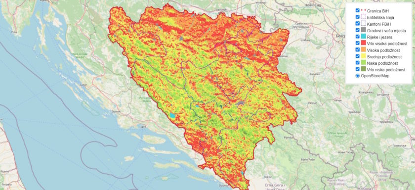
Bosnia and Herzegovina has drafted the first interactive GIS (geographic information system) map of locations vulnerable to forest fires, in an attempt to reduce occurrence. Its authors identified key risk factors and priority areas for preventive measures.
The interactive map of locations vulnerable to forest fires is available on the website Za šume bez vatre, developed as part of the project Joint Action to Reduce Increased Risk of Forest Fires to Nature and People in the Context of Climate Change in Bosnia and Herzegovina.
The map and a draft of the roadmap for forest fire risk reduction were presented at a workshop organized by the Forestry and Environment Initiative – FEA in Banja Luka. It was attended by the representatives of relevant institutions and public forestry companies, the Center for Civil Society Promotion (CPCD) said on the website dedicated to the project SMART Balkans – Civil Society for Shared Society in the Western Balkans.
Lejla Hukić, the project coordinator, said the map is important for improving the understanding of and response to the risk of forest fires in BiH. Its use should also significantly boost resilience to the fires and result in lowering the damage, in her view.
The map is the result of cooperation between government institutions and civil society
Map preparation included the collection, analysis and visualization of data on areas exposed to fire risk.
The authors have identified the key risk factors and determined priority areas for preventive measures.
It is important to point out that the map will benefit all relevant stakeholders – from decision makers and institutions to the local community and citizens, Hukić said.
She noted that the map is the result of cooperation between government institutions and the civil society.
According to Miroslav Rakita, representative of the Landscape Fire Management program in the Western Balkans, the map is one of the first of its kind in the region.
Rakita: The burnt area in the Republic of Srpska is not 100,000 hectares, as official data say, but 200,000
He commended the use of the European Forest Fire Information System (EFFIS) database as reliable and quite accurate, unlike official data. For example, in his words, the burned area over the last 20 years in the Republic of Srpska spans 200,000 hectares, but officially only 100,000 hectares.
The Republic of Srpska is one of the two entities making up BiH. The other one is called the Federation of BiH.
“I can conclude that satellites don’t lie and I believe data used this way is more relevant than official data, which is often not regularly updated,” Rakita said.
The Smart Balkans project is implemented by CPCD in cooperation with partner organizations from Albania – Institute for Democracy and Mediation (IDM), and North Macedonia – Center for Research and Policy Making (CRPM).


Be the first one to comment on this article.